This is an example of a chloropleth map (states identified as republican or democrat in 2000 election):

This is a dot density map of people living with HIV/AIDS in Sub-Saharan Africa. Note the high density of dots in Malawi. I went there this summer!

This is one example of an isarithmic map showing Americans' stance on abortion:

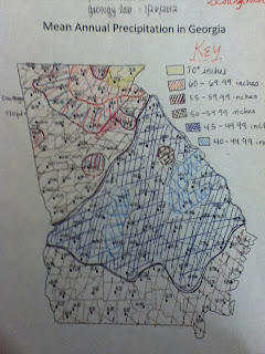
This is another example of an isarithmic map showing Americans' political identification:

Ah. Wine. This is an example of a proportional symbol map. I'm going to Europe ASAP (just kidding).